Find Tide Tables
- Bangor
- Bar Harbor
- Bath
- Biddeford, Saco River
- Camp Ellis, Saco River Entrance
- Coffins Point
- Cutler Farris Wharf
- Cutler, Naval Radio Station
- Eastport
- Ellsworth, Union River
- Fort Point, Penobscot River
- Fort Popham, Hunniwell Point
- Gardiner
- Garnet Point, Pennamquan River
- Gravelly Point, Whiting Bay
- Kennebunkport
- Mackerel Cove, Swans Island
- Millbridge, Narraguagus River, Maine
- Oceanville, Deer Isle
- Pettegrove Point, Dochet Island
- Pine Point, Scarborough River
- Portland
- Pulpit Harbor, North Haven Island
- Richmond
- Rockland
- Seavey Island
- Thomaston
- Walpole
- Wells, Webhannet River
- Winterport
- Amelia Earhart Dam, Mystic River
- Annisquam, Lobster Cove
- Beverly, Beverly Harbor
- Boston
- Boston Light
- Brant Rock, Green Harbor River
- Cape Cod Canal, Bourne Bridge
- Cape Cod Canal, Bournedale
- Cape Cod Canal, RR. bridge
- Cape Cod Canal, Sagamore
- Chappaquoit Point, West Falmouth Harbor
- Chatham
- Chatham, Stage Harbor
- Chelsea St. Bridge, Chelsea River
- Clarks Point
- Duxbury, Duxbury Harbor
- Edgartown
- Essex
- Fall River
- Gloucester Harbor
- Gray Gables
- Great Hill
- Hyannis Port
- Lynn, Lynn Harbor
- Martha's Vineyard GPS Buoy
- Menemsha Harbor, MA
- Merrimacport
- Nantucket Island
- New Bedford Harbor
- Newburyport
- Nut Island, Quincy Bay
- Penikese Island
- Piney Point
- Plum Island Sound (south end)
- Plum Island, Merrimack River Entrance
- Plymouth
- Provincetown
- Riverside
- Rockport
- Round Hill Point
- Salem, Salem Harbor
- Salisbury Point
- Sandwich Marina, Cape Cod Canal, east entrance
- Saquatucket Harbor
- Scituate, Scituate Harbor
- Sesuit Harbor, East Dennis
- VINEYARD HAVEN, VINEYARD HVN HBR
- Weymouth Fore River Bridge
- Woods Hole
- Bay Spring, Bullock Cove
- Block Island (Old Harbor)
- Bristol Ferry
- Bristol Highlands
- Conimicut Light
- East Greenwich
- KICKAMUIT RIVER
- Newport
- Pawtuxet, Pawtuxet Cove
- Point Judith, Harbor of Refuge
- Providence
- Quonset Point
- Rumford, Seekonk River
- Sakonnet
- Southwest Point, Block Island
- Weekapaug Point, Block Island Sound
- West Jamestown, Dutch Island Harbor
- Wickford
- ALBANY
- Baldwin, Parsonage Cove, Hempstead Bay
- Bay Park, Hewlett Bay
- Bayonne Bridge, Bergen Point
- Bayville Bridge
- Beach Channel (bridge)
- Beacon, Flushkill
- Brooklyn Bridge
- Cedar Beach
- Cold Spring Harbor
- Coxsackie, Hudson River
- Dyckman Street, Ferry Slip
- East Rockaway Inlet, Atlantic Beach
- Eatons Neck Point
- Fire Island Coast Guard Station
- Glen Cove, Hempstead Harbor
- Great Kills Harbor
- Green Island
- Greenport
- Harlem River, Randalls Island
- Harry Tappen Marina, Hempstead Harbor
- Haverstraw
- Horns Hook, East 90th Street
- Hyde Park
- Kings Point
- Kingsborough, Sheepshead Bay
- Lake Montauk
- Lloyd Harbor, Huntington Bay
- Long Beach, Bridgewater Yacht Club, New York
- Mattituck Inlet
- Montauk
- Moriches Coast Guard Station
- Moriches Inlet
- North Channel Bridge, Grassy Bay
- Northport, Northport Bay
- Northville
- Norton Point, Head of Bay
- Orient
- Patchogue
- Plum Gut Harbor, Plum Island
- Point Lookout (marina), Jones Inlet
- Ponquoque Point
- Port Jefferson
- Port Morris (Stony Point)
- Port Washington, Manhasset Bay
- Queensboro Bridge
- Rye Beach
- Sag Harbor
- Seaview Ferry Dock
- Shinnecock Inlet (ocean)
- Shinnecock Yacht Club, Penniman Creek
- Silver Eel Pond, Fishers Island, N.Y.
- Smith Point Bridge, Narrow Bay
- South Jamesport
- The Battery
- Throgs Neck, Fort Schuyler
- Turkey Point Hudson River NERRS
- USCG Station NY
- Willets Point
- Williamsburg Bridge
- Worlds Fair Marina, Flushing Bay
- Atlantic City
- Barnegat Inlet, USCG Station
- Bidwell Creek entrance
- Bivalve, Maurice River
- Burlington, Delaware River
- Cape May
- Cheesequake Creek, Garden State Parkway
- Fieldsboro, N.J.
- Fortescue Creek
- Keasbey
- Longport (inside), Great Egg Harbor Inlet
- Mays Landing, Great Egg Harbor River
- New Brunswick
- Old Bridge, South River
- Paulsboro, Mantua Creek, N.J.
- Port Elizabeth
- Port Reading, Arthur Kill
- Red Bank, Navesink River
- Sandy Hook
- Sayreville
- Ship John Shoal
- Steelmanville, Patcong Ck., 2.5 nm above ent.
- Stone Harbor, Great Channel
- Stouts Creek
- Tacony-Palmyra Bridge
- Toms River (town), Toms River
- Trenton, N.J.
- Tuckahoe, Tuckahoe River
- Tuckerton, Shooting Thorofare, Little Egg Inlet
- Ventnor City, ocean pier
- Wildwood Crest, ocean pier
- Annapolis
- Baltimore
- Barren Island
- Bishops Head
- Bladensburg, Md.
- Buntings Bridge
- Cambridge
- Chesapeake City
- Cove Point
- Crisfield, Little Annemessex River
- Crumpton
- Ewell, Smith Island
- Fort McHenry Marsh
- Havre de Grace
- Hillsboro, Tuckahoe Creek
- Kent Point Marina
- Long Beach
- Love Point
- Lower Marlboro
- Matapeake, Kent Island
- McCreedy's Creek, Fishing Bay
- OCEAN CITY (FISHING PIER)
- Ocean City Inlet
- Pond Point, Bush River
- Poplar Island
- Public Landing
- Salisbury, Wicomico River
- Sassafras River, Betterton
- Sharptown
- Smithville Road Bridge, Beaverdam Creek
- Snowhill, city park
- Solomons Island
- South Point, Sinepuxent Neck
- Tolchester Beach
- Town Point Wharf
- Vienna
- CBBT, Chesapeake Channel
- CHESAPEAKE BAY BRIDGE TUNNEL
- Chincoteague Channel (south end)
- Chincoteague Island, USCG Station
- City Point, Hopewell
- Colonial Beach, Va.
- Dahlgren
- Fort Eustis (MARAD)
- Gaskins Point, Occohannock Creek
- Gloucester Point
- Jamestown
- Jesters Island
- Kingsmill
- Kiptopeke
- Lafayette River
- Lanexa, Chicahomny River
- Lester Manor
- Lewisetta
- Money Point
- Park Turn
- Portsmouth, Naval Shipyard
- Puddledock, Appomattox River
- Rappahannock Light
- Richmond (river locks)
- Richmond Deepwater Terminal, James River
- Rudee Inlet, interior channel
- Saxis, Starling Creek
- Scotland
- Sewells Point
- Southern Chincoteague Island
- Tangier Island
- Tettington, James River
- Wachapreague
- Wares Wharf
- Western Branch
- Willcox Wharf, Charles City
- Windmill Point
- Yorktown USCG Training Center
- Atlantic Beach
- Beaufort, Duke Marine Lab
- Bowen Point, Shallotte Inlet
- CAPE HATTERAS FISHING PIER
- Cape Lookout Bight
- Cedar Island
- Core Creek Bridge
- Davis, Core Sound
- Duck
- Engelhard
- Hampstead
- Manns Harbor, Croatan Sound
- Morehead City Harbor
- Oak Island, Yaupon Beach
- Ocracoke, Pamlico Sound
- Old House Channel
- Oregon Inlet (USCG Station)
- Oregon Inlet Marina
- Oriental, Neuse River
- Oyster Creek, Croatan Sound
- Peter's Ditch
- Pungo River, Route 45, NC
- Roanoke Marshes Light, Croatan Sound
- Rodanthe, Pamlico Sound
- Shinn Point, ICWW
- Sneads Ferry, New River
- Southport
- SpoonersCreek
- Sunny Point Army Base, Wharf no.3
- Sunset Beach Pier
- Swansboro, East Corbett Ave. Bridge
- USCG Station Hatteras
- Varnamtown, Lockwoods Folly River
- Wilmington
- Wrightsville Beach
- Zekes Island
- Air Station Beaufort, McCalleys creek
- Beaufort
- Bennet's Dock, Pawleys Island Creek
- Brighton Beach. May River
- Buck Hall, Awendaw Creek
- Bucksport
- Cainhoy
- Capers Creek, South Capers Island
- Charleston
- Clambank Creek, Goat Island, North Inlet
- Corning Landing, Whale Branch
- Fripps Inlet, Hunting Island Bridge
- Garden City Bridge, Main Creek
- Garden City Pier (ocean)
- General Dynamics Pier
- Georgetown, Sampit River Ent.
- Goose Creek entrance
- Hollywood, Wadmalaw River
- I-526 bridge
- North Charleston, Ashley river
- Oaks Creek, upper end
- Oyster Landing (N. Inlet Estuary)
- Pawleys Island Pier (ocean)
- Skull Creek, north entrance, Hilton Head Island
- South Santee River, ICWW, 4 Mi Canal Creek
- Springmaid Pier
- Thoroughfare Creek entrance
- Waccamaw River Entrance
- Wachesaw Landing, Waccamaw River
- Ward's Dock, Pawleys Inlet
- White House Woods, Mosquito Creek
- Windsor Plantation, Black River
- Bailey Cut, 0.8 mile west of
- Bear River Entrance
- Bear River, (Range 'A' Light)
- Crispen Island
- Daymark #156, Head of Mud River
- Fort Pulaski
- Halfmoon Reef, Halfmoon River
- Howe Street Pier, Brunswick
- Kings Bay MSF Pier
- Kings Bay, Navy Base
- Little Wassaw Island, Green Island Sound
- Port Wentworth
- Priest Landing, Wilmington River
- Raccoon Key Spit
- Richmond Hill, Ogeechee River
- Rockdedundy River (Daymark 185)
- Seacamp Dock, Cumberland Island
- Skidaway Institute, Skidaway River
- South Newport River (Daymark 135)
- St. Marys
- St. Simons Light
- Sunbury, Medway River
- Anclote Key, southern end
- Ankona
- Apalachicola
- Bald Point, Ochlockonee Bay
- Ballast Point
- Bayport
- Big Lagoon
- Bings Landing, Matanzas River
- Black Creek, S.C.L. RR. bridge
- Blue Angels Park
- Boca Chica Marina
- Boca Chita Key, Biscayne Bay
- Boca Raton, Lake Boca Raton
- Bokeelia, Charlotte Harbor
- Buffalo Bluff
- Cape Coral Bridge
- Cape San Blas, Western Cape
- Captiva Island (outside)
- Carlos Point, Estero Bay
- Cat Point, Apalachicola Bay
- Cedar Heights, Broward River
- Cedar Key
- Chassahowitzka, Chassahowitzka River
- Chester, Bells River
- Clapboard Creek, Pelotes Island
- Clearwater Beach
- Cocoa Beach
- Coconut Point
- Coon Key
- Courtney Point
- Crandall
- Crescent Beach, Matanzas River
- CUT 1N FRONT RANGE, ST MARYS RIVER ENTR
- Cutler, Biscayne Bay
- Dames Point
- Deer Point Lake, Hwy 2321 bridge, North Bay
- Deerfield Beach, Hillsboro River
- Dixie Bay, Salt River, Crystal Bay
- Dog Island, East End
- Don Pedro Island State Park, Cutoff (south)
- Driftwood Point, Choctawhatchee Bay
- East Arsenicker, Card Sound
- East Bay
- East Bayou, Hwy 65 bridge, East Bay
- Econfina River
- Edwards Creek, 1 mi. above entrance
- Egmont Key, Egmont Channel
- Eleven Mile, St. Vincent Sound
- Ellenton, Manatee River
- Elliott Key Harbor, Elliott Key, Biscayne Bay
- Estero Island, Estero Bay
- Fernandina Beach
- Fishing Bend, Santa Rosa Sound
- Fleming Key, north end
- Floridatown, Escambia Bay
- Fort Lauderdale, Andrews Ave. Bridge
- Fort Myers
- Fort Pierce Inlet, Binney Dock
- Fort Pierce, South Beach Causeway
- Goose Point, East Bay
- GOVERNMENT CUT, MIAMI HARBOR ENTRANCE
- Hagens Cove
- Halls River bridge, Homosassa River
- Haulover Pier, N. Miami Beach
- Hawkins Rec. Park, Blackwater River
- Hendry Creek, Estero Bay
- Hernandez Point, Escambia Bay
- Hillsboro Inlet Marina
- Holley, East Bay
- HORSESHOE POINT
- Huckleberry Landing, Jackson River
- I-295 Buckman Bridge
- Indian Pass, St. Vincent Sound
- Jacksonville Beach
- Jacksonville, Long Branch
- Jensen Beach Causeway Park
- Johns Island, Chassahowitzka Bay
- Keewaydin island (inside)
- Key Colony Beach
- Key West
- Kings Bay
- Lake Wimico
- Lake Worth ICW
- Lake Worth Pier, Atlantic Ocean
- Lake Wyman, ICWW
- Lanark, St. George Sound
- Lauderdale-by-the-Sea, Anglin Fishing Pier
- Little Card Sound bridge
- Little Hickory Island
- Little Manatee River, US 41 Bridge
- Little St. George Island, Horseshoe Cove
- Locust Point, Hog Island
- Lofton, Lanceford Creek
- Loggerhead Key, Dry Tortugas
- Lora Point, Escambia Bay
- Manasota, Lemon Bay
- Mangrove Pt., Crystal Bay
- Marco Island, Caxambas Pass
- Marco, Big Marco River
- Mary Esther, Santa Rosa Sound
- Mason Creek, Homosassa Bay
- Matanzas Inlet, State Road A1A Bridge
- Matlacha Pass (bascule bridge)
- Mayport (Bar Pilots Dock)
- Mayport (Ferry Depot)
- Mayport Naval Station, Degausing Structure
- Mayport Naval Station, Water Treatment Dock
- McIlvaine Bay
- McKay Bay Entrance
- Melbourne Causeway
- Miami Harbor Entrance
- Miami Miamarina, Biscayne Bay
- Millview, Perdido Bay
- Mullet Key Channel (Skyway)
- Myakka River, US 41 bridge
- Naples (outer coast)
- NAPLES BAY, NORTH
- Nassauville
- Navarre Beach
- Navarre, North Side, East Bay
- New Smyrna Beach
- NEWMAN BRANCH
- North Captiva Island
- Ocean Ridge, ICWW
- Okaloosa Island
- Old Port Tampa
- Overstreet
- Ozello north, Crystal Bay
- Ozello, St. Martins River
- Packwood Place, Mosquito Lagoon
- Palatka
- Panacea, Dickerson Bay
- Panama City
- Panama City Beach
- Pensacola
- Pensacola Beach Pier
- Peoria Point, Doctors Lake
- PGA Boulevard Bridge, ICWW
- Phoenix Park
- Piney Bluff Landing
- Ponce de Leon Inlet
- Port Boca Grande, Charlotte Harbor
- Port Leon
- Port Manatee
- Port of Palm Beach
- Port Saint Joe, St. Joseph Bay
- Pumpkin Bay
- Pumpkin Key, south end, Card Sound
- Punta Rassa, San Carlos Bay
- Racy Point, St Johns River
- Red Bay Point, St Johns River
- Rocky Bayou, Choctawhatchee Bay
- Safety Harbor, Old Tampa Bay
- Sand Key Lighthouse, Sand Key Channel
- Santa Rosa, Hogtown Bayou
- Sewall Point
- Shell Island, north end
- Shell Mound
- Shell Point, Peace River, Charlotte Harbor
- Shell Point, Walker Creek
- Sherwood Forest
- Shield Point, Blackwater River
- Siesta Key, Big Sarasota Pass
- Sisters Creek
- Smith Shoal Light
- Snipe Island, Econfina River State Park
- South Carrabelle Beach
- South Delray Beach, ICWW
- South Point, St. Lucie Inlet
- South Port Everglades
- Southbank Riverwalk, St Johns River
- Spring Warrior Creek
- St. Augustine Beach
- St. George Island, Northeast End
- St. George Island, Sikes Cut
- St. James City, Pine Island
- St. Joseph Point, St. Joseph Bay
- ST. MARKS RIVER ENTRANCE
- St. Marks, Wakulla River
- St. Petersburg
- State Road 312, Matanzas River
- Sulphur Point, Port of Panama City
- Tarpon Bay, Sanibel Island
- Tolomato River (ICWW)
- Trident Pier, Port Canaveral
- Tuckers Island, Homosassa River
- Turkey Point, Biscayne Bay
- Turkey Point, St. James Island
- Turtle Bay
- Turtle Mound, Mosquito Lagoon
- Twin Rivers Marina
- Vaca Key, Florida Bay
- Valparaiso
- Vaughns Landing
- Venice Municipal Airport
- Vero Beach
- Vilano Beach, Tolomato River
- Virginia Key
- Wakulla Airport, Ochlockonee Bay
- Welaka
- West Bay Creek, West Bay
- WHITE BEACH, EAST BAY
- White City, Gulf County Canal
- White City, ICWW
- Woodlawn Beach, Santa Rosa Sound
- Alabama Point
- Arnica Bay, Mill Point
- Bayou La Batre Bridge
- Chickasaw Creek
- Coast Guard Sector Mobile
- Dauphin Island
- Dauphin Island Hydro
- Dog River Bridge
- East Fowl River Bridge
- Fly Creek, Mobile Bay
- Gulf Shores, ICWW
- Gulf State Park Pier
- Lower Bryant Landing
- Meaher State Park, Mobile Bay
- Mobile State Docks
- Point Clear, Mobile Bay
- Weeks Bay
- West Fowl River Bridge
- Wolf Bay
- Bay Waveland Yacht Club
- Biloxi
- Dock E, Port of Pascagoula
- Grand Bay NERR, Mississippi Sound
- Graveline Bayou Entrance
- Gulfport Harbor, Mississippi Sound
- Handsboro Bridge, Bernard Bayou
- Horn Island, Mississippi Sound
- Ocean Springs
- Pascagoula NOAA Lab
- Pascagoula, Mississippi Sound
- Pascagoula, South Side
- Petit Bois Island, Mississippi Sound
- Ship Island, Mississippi Sound
- Waveland
- Bay Pomme D'or
- Bayou Chene
- Bayou Faleau
- Bayou Fearman, Vermillion Bay
- Berwick, Atchafalaya River
- Bulk Terminal
- Calcasieu Pass
- Caminada Pass (bridge)
- Catfish Point, Mermentau River
- Cocodrie, Terrebonne Bay
- Cypremort Point
- Devon Energy Facility
- E. ISLE DERNIERES, LAKE PELTO
- East Bank 1, Norco, B. LaBranche
- East Calcasieu Lake
- East Sabine Lake
- East Timbalier Island, Timbalier Bay
- Eugene Island, North of, Atchafalaya Bay
- Fourleague Bay
- Freshwater Bayou
- Freshwater Canal Locks
- Golden Meadow, Plaisance Canal
- Grand Bay
- Grand Isle
- Grand Pass
- Gum Cove, ICWW
- Intracoastal City
- Joseph Harbor
- Lafitte, Barataria Waterway
- Lake Charles
- LAWMA, Amerada Pass
- Leeville, Bayou LaFourche
- MARTELLO CASTLE, LAKE BORGNE
- Mendicant Island, Barataria Bay
- Mermentau River, Grand Chenier
- New Canal Station
- Pilots Station East, S.W. Pass
- Pilottown
- Pointe Au Chien, Cut Off Canal
- Port Fourchon, Belle Pass
- Rat Bayou
- Schooner Bayou, Vermillion Bay
- Shell Beach
- SOUTH PASS
- Stouts Pass at Six Mile Lake
- SW Pass
- TEXACO DOCK, HACKBERRY BAY
- Texas Gas Platform, Caillou Bay
- The Rigolets, U.S. Highway 90
- Weeks Bay
- Aransas Wildlife Refuge
- Aransas, Aransas Pass
- Barroom Bay
- Battleship Texas State Park
- Bayside, Copano Bay
- Buffalo Bayou, Houston Ship Channel
- Clear Lake
- Conn Brown Harbor, Aransas Pass
- Copano Bay
- Corpus Christi Naval Air Station
- Corpus Christi, Bob Hall Pier
- COX WC-53 Platform
- Cypress, San Jacinto River
- Eagle Point, Galveston Bay
- Enbridge, Ingleside
- Fieldwood WC-289 Platform
- Freeport Entrance Jetty
- Freeport Harbor
- Freeport Harbor
- Galveston Bay Entrance, North Jetty
- Galveston Bay Entrance, South Jetty
- Galveston Pier 21
- Galveston Pleasure Pier
- Galveston Railroad Bridge
- High Island
- Jamaica Beach, West Bay
- La Quinta Channel North
- Lynchburg Landing, San Jacinto River
- Manchester
- Matagorda Bay Entrance Channel
- Matagorda City
- Morgans Point, Barbours Cut
- Nueces Bay
- Old Brazos River, Freeport
- Packery Channel
- PADRE ISLAND (south end)
- Padre Island, Port Mansfield Channel Ent.
- Port Aransas
- Port Aransas (H. Caldwell Pier)
- Port Arthur
- Port Bolivar
- Port Isabel
- Port Lavaca
- Port O'Connor
- Portland, Nueces Bay
- Rainbow Bridge
- Realitos Peninsula
- Renaissance SA-13 Platform
- Rockport
- Rollover Pass
- Round Point, Trinity Bay
- Sabine Offshore Light
- Sabine Pass
- San Luis Pass
- San Martin Lake Channel
- Sargent
- Seadrift
- Shoalwater Flats, Espiritu Santo Bay
- Sievers Cove, Goat Island
- Smith Point
- South Padre Island CG Station
- SPI Brazos Santiago
- Texas City, Galveston Bay
- Texas Point, Sabine Pass
- Umbrella Point, Trinity Bay
- USCG Freeport
- USS Lexington, Corpus Christi Bay
- Viola Turning Basin
- White Point
- Alameda
- Antioch
- Arena Cove
- Avalon, Santa Catalina Island
- Berkeley
- Blackslough Landing
- Bolinas Lagoon
- Bradmoor Island, Nurse Slough
- Cockrobin Island Bridge, Eel River
- Corte Madera Creek
- Coyote Creek, Alviso Slough
- Crescent City
- Crockett
- Dumbarton Highway Bridge
- Elkhorn Slough railroad bridge
- Elkhorn, Elkhorn Slough
- Fields Landing
- Gaviota State Park, Pacific Ocean
- Green Cove
- Hunters Point
- Kirby Park, Elkhorn Slough
- Korths Harbor, San Joaquin River
- La Jolla
- Long Beach, Terminal Island
- Los Angeles
- Mallard Island Ferry Wharf
- Mansfield Cone
- Mare Island
- Martinez-Amorco Pier
- Mission Bay, Campland
- Monterey
- Newport Bay Entrance, Corona del Mar
- North Spit
- NOYO HARBOR
- Oakland Harbor, Park Street Bridge
- Oakland Inner Harbor
- Oil Platform Harvest
- Pillar Point Harbor, Half Moon Bay
- Pinole Point
- Point Reyes
- Port Chicago
- Port of West Sacramento, Washington Lake
- Port San Luis
- Pyramid Point, Smith River
- Redwood City
- Richmond
- Rincon Island, Mussel Shoals
- Rincon Point, Pier 22 1/2
- Rio Vista
- Samoa
- San Diego
- San Francisco
- San Leandro Marina
- San Mateo Bridge (west end)
- Santa Barbara
- Santa Monica
- Shelter Cove
- Sonoma Creek
- South San Diego Bay
- Suisun Slough entrance
- Threemile Slough entrance
- Tidal Creek, Elkhorn Slough
- Wards Island, Little Connection Slough
- Wilson Cove, San Clemente Island
- Astoria
- Cascade Head, Salmon River
- Cathcart Landing, Youngs River
- Charleston
- Chinook Bend, Siletz River
- Cushman, Siuslaw River
- Depoe Bay
- Dick Point
- Florence USCG Pier, Siuslaw River
- Garibaldi
- Gold Beach, Rogue River
- Hammond, Oregon
- North Fork, Nehalem River
- North Jetty, Tillamook Bay
- Port Orford
- Portland Morrison Street Bridge
- Reedsport
- Rink Creek Entrance, Coquille River
- Rocky Point
- South Beach
- St Helens
- Umpqua River Entrance, Half Moon Bay
- Waldport, Alsea Bay
- Wauna
- Weiser Point, Yaquina River
- ABERDEEN
- Armitage Island, Thatcher Pass
- Bangor Wharf
- Barlow Point
- Beacon Rock State Park
- Blaine, Semiahmoo Bay
- Bremerton
- Budd Inlet, Olympia Shoal
- Cape Disappointment
- Cape Horn
- Cherry Point
- Deception Pass St. Park, Bowman Bay, Fidalgo I.
- Everett
- Foulweather Bluff
- Friday Harbor
- Greenbank, Whidbey Island
- Greenhead Slough
- Hanbury Point, Mosquito Pass, San Juan I.
- Jim Creek
- Kanaka Bay, San Juan Island
- Knapp Landing, Willow Bar
- La Push, Quillayute River
- Longview
- NAS Whidbey Island
- Neah Bay
- POINT ROBERTS, PUGET SOUND
- Port Angeles
- Port Townsend
- Priest Point
- Richardson, Lopez Island
- Rosario, East Sound, Orcas Island
- SANDY POINT ANDERSON ISLAND, PUGET SOUND
- Seattle
- Sekiu, Clallam Bay
- Skamokawa
- Sneeoosh Point
- South Bend, Willapa River
- Spee-Bi-Dah
- Swinomish Channel ent., Padilla Bay
- Tacoma
- TELEGRAPH BAY, PUGET SOUND
- TEMCO Kalama Terminal
- Toke Point
- Tskawahyah Island, Cape Alava
- Tulalip
- Tulare Beach, Port Susan
- Turner Bay, Similk Bay
- Union
- Upright Head, Lopez Island
- Vancouver
- Village Point, Lummi Island
- WALDRON ISLAND, PUGET SOUND
- Washougal
- Wauna, Carr Inlet
- Westport
- Yoman Point, Anderson Island, Balch Passage
- 5 miles NE of Point Brazil, Montague Island
- Adak Island
- Agnes Cove, Aialik Peninsula
- Aguchik Island, Kukak Bay
- Aialik Bay, North end
- Aialik Sill, Aialik Bay
- Akun Cove, Akun Island
- Akutan, Akutan Island
- Alakanuk, Yukon River
- Alitak
- Anchor Point
- Anchor Point
- Anchorage
- Atka
- Bainbridge Point, Bainbridge Island
- Baranof, Warm Spring Bay
- Barrow Offshore
- Barter Island
- Bartlett Cove, Glacier Bay
- Bay of Isles, South Arm
- Bear Cove, Kachemak Bay
- Beecher Pass
- Bethel
- Bird Island
- Blaquiere Point
- Bradfield Canal, Ernest Sound
- Broad Bight, Akutan Island
- Buckland, Buckland river
- Burrough Bay, Behm Canal
- Bushy Island, Snow Passage
- Camp Cove, Aialik Bay
- Cape Chunak, AK
- Cape Constantine, Nushagak Penninsula
- CAPE ESPENBERG, KOTZEBUE SOUND
- Cape Hinchinbrook
- Cape Kasilof
- Cape Krusenstern
- Cape Peirce, West Side
- Cape Sarichef
- Carter Bay, Kuskokwim Bay
- Castle Bay, Northwest Arm
- Castle Islands, Duncan Canal
- Chefornak, Kinia River
- Chilkat Inlet
- Chinulna Point, Cook Inlet
- Chirikof Island
- Chowiet Island, Semidi Island
- Cold Bay
- College Fiord
- Cordova
- Craig, Klawock Inlet
- Crater Bay, Harris Bay
- Custom House Cove, Mary Island
- Dago Creek Mouth, Ugashik Bay
- Dall Point
- Deering
- Dolgoi Harbor, Dolgoi Island
- Egegik, Egegik River
- El Capitan Passage, Dry Pass
- El Capitan Passage, W. of Aneskett Pt.
- Elfin Cove
- Emmonak, Kwiguk Pass, Yukon River
- Entrance Island
- False Bay, Chatham Strait
- False Pass, Isanotski Strait
- Fire Island
- Golf Island, Necker Island
- Golovin, Golovnin Lagoon Entrance
- GOODHOPE BAY, KOTZEBUE SOUND
- Goodnews Bay, ANVSA
- Goose Creek, Knik Arm, Cook Inlet
- Gravina River
- Green Bight, Akutan Island
- Guguak
- Hawk Inlet Entrance
- Helmick Point, southeast of
- Herendeen Island, Shumagin Islands
- Herring Point
- Homer, Coal Point, Kachemak Bay
- Hoonah, Port Fredrick
- Hump Island, Kuiukta Bay
- HYDABURG, SUKKWAN STRAIT
- Hyder, Portland Canal
- Isanotski Strait Entrance, Ikatan Bay
- Ivanof Bay
- Japanese Bay
- Juneau
- Kake Harbor, Keku Strait
- Kalgin Island (north end), Cook Inlet
- Kasitsna Bay, Kachemak Bay
- Ketchikan
- King Cove
- Kipnuk, Kugkaktlik River
- Kivalina
- Kodiak Island
- Kotlik, Kotlik River
- Kotzebue
- Koyuk, Koyuk Inlet
- Kulukak Point, Kulukak Bay
- Kun River, Scammon Bay
- Larsen Bay
- Leconte Bay
- Levelock
- Lindeman Cove
- Lomavik
- Lost River, Seward Peninsula
- Madan Bay
- Magnetic Point, Union Bay, Earnest Sound
- MASSACRE BAY
- McCarty Fiord, Moonlight Bay
- Mekoryuk, Mekoryuk River Ent., Nunivak Island
- Meshik, Port Heiden
- Metlakatla, Port Chester
- Mitrofania Island
- Monte Carlo Island
- Moraine Bay, Icy Bay
- Nachalni Island
- Naknek, Naknek River
- Nelson Island, Tooksook Bay
- Neumans Cove, Unimak Island
- Newtok, Ningliq River
- Nikiski
- Nikolski
- Ninilchik
- Nome, Norton Sound
- North Foreland
- Northeast Cape
- Nossuk Bay, Tonowek Bay
- Nukshak Island, Shelikof Strait
- Nunam Iqua (Sheldon Point)
- Nushagak Bay (Clarks Point)
- Old Harbor
- Ouzinkie, Spruce Island
- Papke's Landing
- Pelican Harbor, Lisianski Inlet, AK
- Perch Point
- Perry Island (South Bay)
- Platinum
- Point Elrington, Elrington Island
- Point Harrington
- Point Hope
- Point Lockwood, Woewodski Island
- Point Possession
- Point Spencer, Port Clarence
- Popokamute (Kokokamute), Kuskokwim River
- Port Alexander
- Port Houghton (Inside)
- Port Lions, AK
- Port MacKenzie
- Port Moller
- Port Snettisham, Speel River Arm
- Port William, Shuyak Island
- Povorotni Island, Pogibshi Point
- Protection Point
- Prudhoe Bay
- Puale Bay
- Quinhagak (Kwinak), Kanektok River
- Red Bluff Bay
- Red Dog Dock
- Reef Bight, Akutan Island
- Reef Point, Stikine Strait
- Rootok Island
- Saginaw Bay, Kuiu Island
- Sand Point
- Savoonga
- Scotch Cap
- Scraggy Island
- SE Tigalda Island, Pacific Ocean
- Seal Island
- Seldovia
- Serguis Narrows
- Seward
- Shaktoolik
- Sharp Point, Speel Arm
- Sheep Bay
- Shishmaref Inlet
- Sitka
- Skagway, Taiya Inlet
- Snag Point
- Snug Harbor, Chisik Island
- Snug Harbor, Knight Island
- Southwest Iniskin Bay
- St. George, St. George Island
- Stebbins, Norton Sound
- Surf Bay, Akutan Bay
- Target Island, Mitchell Bay
- Tarr Inlet, Glacier Bay
- Teller, Port Clarance
- Tenakee Springs, Tenakee Inlet
- Terror Bay
- The Brothers
- The Summit
- Thomas Bay
- Thoms Point, Zimovia Strait
- Tigalda Bay, Tigalda Island
- Tin City
- Trident Bay, Akun Island
- TROCADERO BAY
- Tuntutuliak
- Turn Point
- Tyndall Glacier, Icy Bay
- Udamat Bay, Sedanka Island
- Umuruk Basin
- Unalakleet
- Unalaska
- Upper Golovnin Lagoon
- Upper Northwestern Fiord, Harris Bay
- Uzkosti Point
- Valdez
- Village Cove, St Paul Island
- Village Rock, Zimovia Strait
- Wainwright, Chukchi Sea
- West Raspberry Island
- White Mountain, Niukluk
- Whitestone Narrows, Neva Strait
- Whittier, Passage Canal
- Wooded Islands
- Wrangell, Wrangell Island
- Yakutat, Yakutat Bay
- Zachary Bay, Unga Island
- Zapadni Bay, St. George Island
- Aguadilla
- Arecibo
- Bahia Salinas
- Boca de Cangrejos
- Boca del Cibuco
- Boqueron
- Ceiba, Roosevelt Road
- Central Aguirre
- Crown Bay, St. Thomas
- Cruz Bay, St. John
- Culebra
- Culebrita
- Esperanza, Vieques Island
- Fajardo
- Fareham Bay, St. Croix
- Grapetree Bay, St, Croix
- Guanica
- Haulover Bay, St. Johns
- Hawksnest Beach, St. John
- Isabel Segunda, Vieques Island
- Isla Palominos
- Jersey Bay, St. Thomas
- Johns Folly Bay, St. John Island
- Joyuda
- Las Mareas
- Luquillo
- Magens Bay, St. Thomas
- Magueyes Island
- Mayaguez
- Mona Island
- Mosquito Pier, Vieques
- Naguabo
- Palmas del Mar
- Pavillion Point, St. Thomas
- Penuelas (Punta Guayanilla)
- Ponce
- Puerto Maunabo
- Puerto Real
- Punta Arenas, Vieques Island
- Punta Guanajibo, Mayagues
- Punta la Plata, Vieques Island
- Salt River Bay, St. Croix
- San Juan, La Puntilla, San Juan Bay
- Santa Isabel
- Southeast Mona Island
- Teague Bay, St. Croix
- Yabucoa Harbor
Browsing History
Popular Tide Tables
What is a Tide Chart?

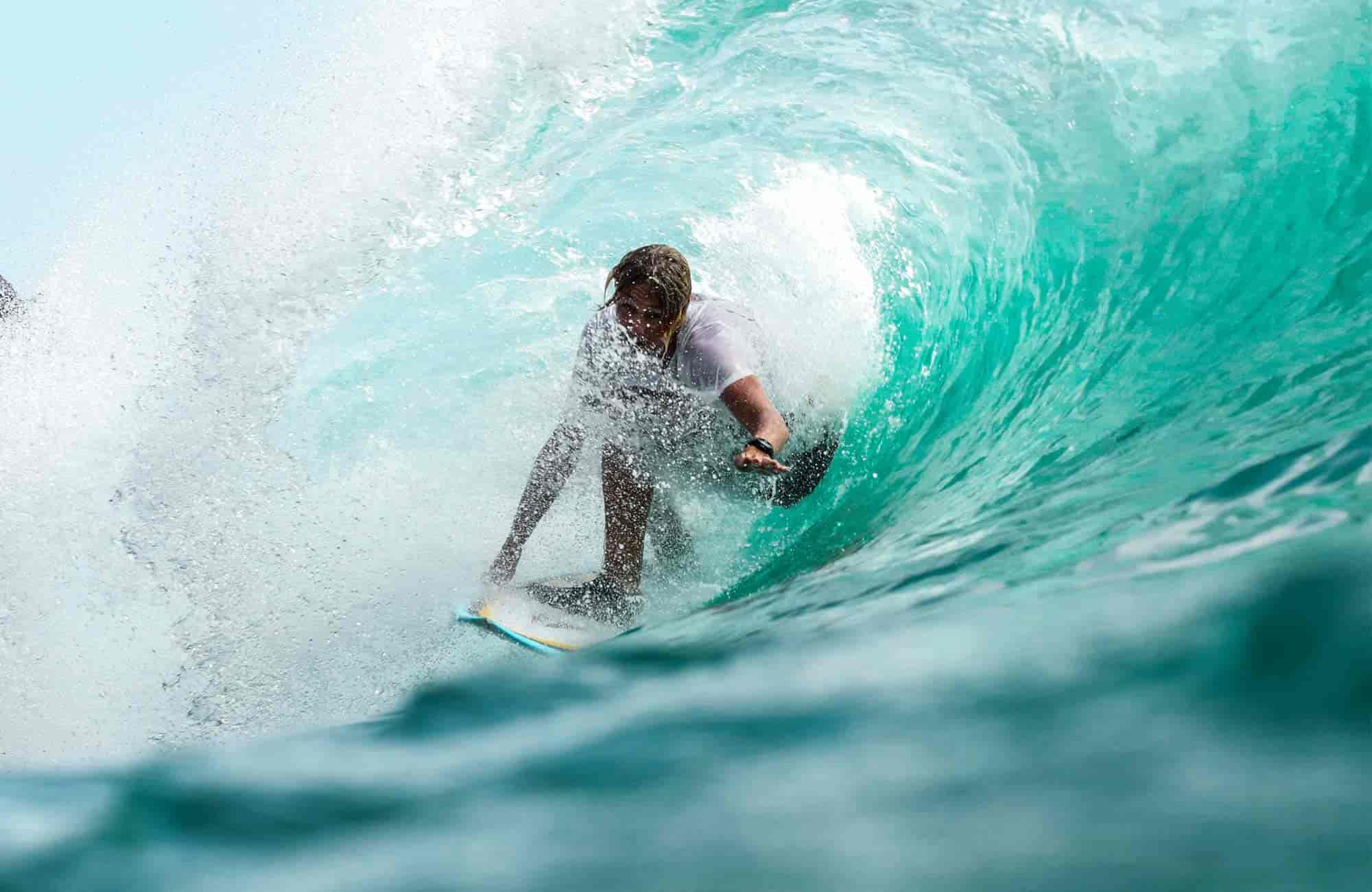
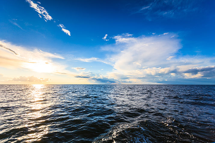
A tide chart is a vital tool for anyone heading to the ocean, predicting the rise and fall of sea levels caused by gravitational forces. For surfers, understanding these cycles is the difference between a world-class session and a long walk on a dry reef. Charts typically display the date, time, and height of High Tide and Low Tide in feet (ft). In the U.S., these heights are measured against MLLW (Mean Lower Low Water), which serves as the "zero" reference point on your graph.
The "Mid-Tide" Sweet Spot: Why Moving Water Matters
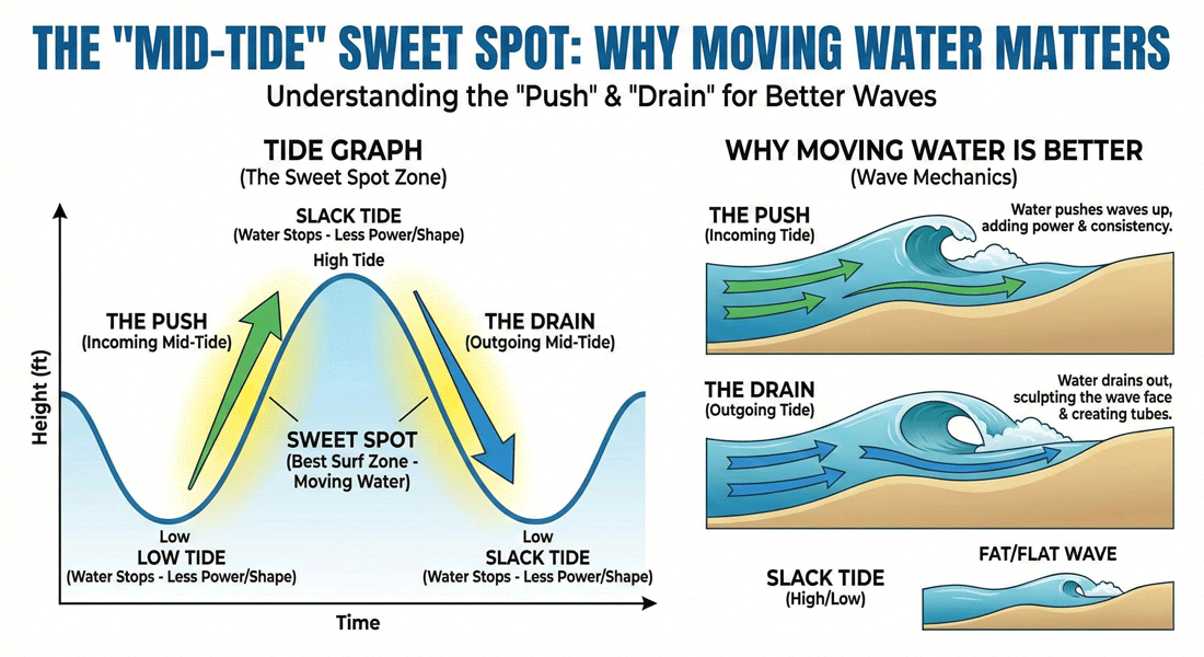
In the surfing world, the most consistent waves often happen during the "Mid-Tide"—the window between the extremes of high and low. As the tide comes in (the Push) or goes out (the Drain), the movement of water creates energy and flow. This "moving water" helps the waves break more predictably and with more power compared to the stagnant periods of peak high or low tide.
How Tide Levels Shape Your Waves
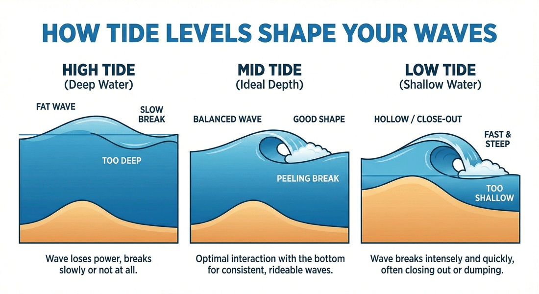
The tide level dictates the depth of the water over the sandbar or reef. This depth is the primary factor in how a wave "breaks":
- High Tide: Often makes waves "Fat" or "Mushy." The water is too deep for the wave to break properly, causing it to lose power or break right on the shore (shorebreak).
- Low Tide: Can make waves "Hollow" or "Pockety." However, if the water is too shallow, waves may "Close-out," meaning the entire line breaks at once, making it unrideable.
Choosing the Right Tide for Your Skill Level
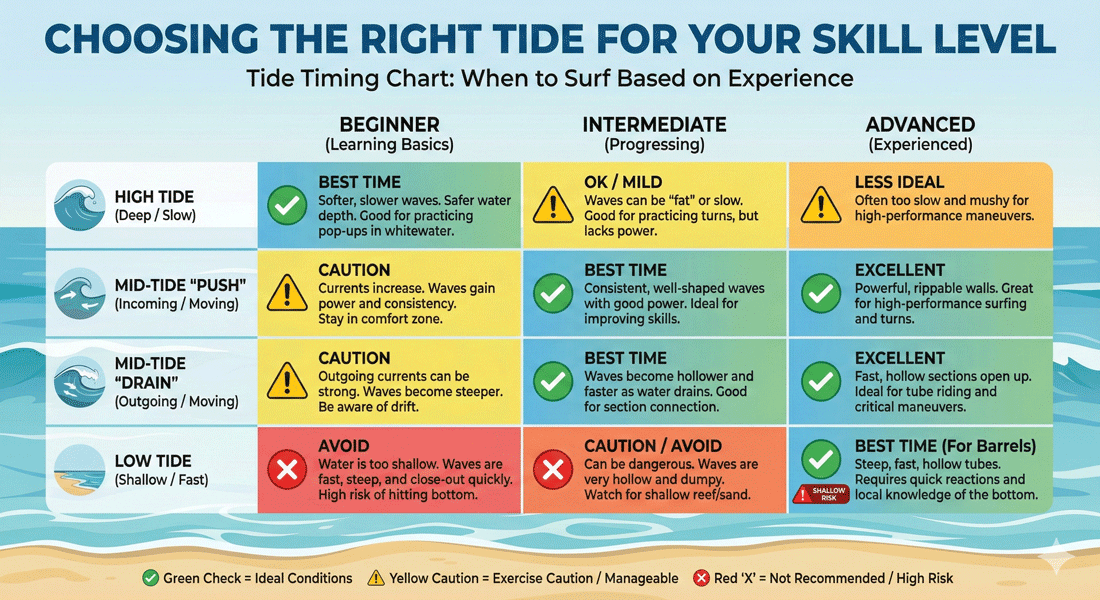
Timing your session is key to safety and fun. Use this guide to plan your next paddle out based on your experience:
Frequently Asked Questions
Tides are primarily caused by the gravitational pull of the moon and the sun on Earth''s oceans as the planet rotates.
Slack water is a short period when the tide is turning (from high to low or vice versa) and there is little to no horizontal movement in the water. Waves often lose their "shape" during this time.
A negative tide (e.g., -1.0 ft) occurs when the water level drops below the average lower low water (MLLW) line. This often reveals tide pools or rocks that are usually submerged.
Yes. While gravitational cycles are constant, seasonal weather patterns, storm surges, and "King Tides" (exceptionally high tides occurring a few times a year) can cause significantly higher water levels than predicted.